Converting Santa Monica Airport into a park: time to talk about time

In case you have lost the thread of these posts, let me reiterate that there are three factors that will affect the planning and construction of the park that will replace Santa Monica Airport: land, money, and time. In the previous two posts I’ve discussed the first two, now it is time’s turn.

For building the park, there needs to be both a short-term calendar and a long-term calendar. That is another way of saying that there can be an ultimate goal, but there also needs to be a way to get to it. You know: a journey of a thousand miles starts with a small step.

The planning process so far has focused on a long-term calendar. (I say “so far,” because as I said in a prior post, I have heard from Sasaki and from city staff that they will be presenting a phasing schedule to City Council.) The planners have asked the public for wish lists of what they would want to see in a park. Specific limitations, such as cost figures or budgets, haven’t been placed on these wishes, although in general terms survey participants have been asked to “balance” costs and revenues.

From these wishes the planners, Sasaki and staff, have developed three scenarios. These scenarios present final, if hypothetical, visions of what the park would look like. Because City Council instructed the planners to make the park revenue neutral, the scenarios, particularly the more ambitious two of the three, include a lot of undefined “revenue generating” uses.

The second of the three scenarios. Note that it includes 35 enumerated uses, not including extensive but largely undefined revenue-generating “development zones” (in beige). Nearly all of these uses would require extensive planning processes of their own before they would need to be put to the voters for approval.

These revenue-generating uses distort the planning process, because, as I’ve discussed previously, they are hardly certain. Not only do we not know how much money they would generate, but also nearly all of them, and all of those that might produce the most revenue, would require a public vote to amend Measure LC. This would require extensive planning processes for these uses before they could go to a vote. We think we are planning a park, but in fact we are planning a hypothesis.

Nonetheless, it is from the wish lists embodied in the scenarios that City Council will, at its meeting July 8, choose the elements to include in the “project” for purposes of environmental review. The plan is that with further public outreach this fall, Sasaki and staff will develop a project that the council will approve in December for the EIR, along with alternatives as required by the California Environmental Quality Act (CEQA).

This is where the timeframe becomes a factor. The council will face the question whether the environmental review should focus on a long-term aspirational project, or a more pragmatic shorter term project.

There are several reasons to focus on the shorter term.

Primarily we need a shorter-term project because the public needs to have faith that when the airport closes there will be a genuine path towards the park. Specifically, in Santa Monica, many extensive public processes have resulted in nothing. More generally, people have lost considerable faith in the ability of government to get good things done.

A side but not insignificant benefit on making the project more short-term is that the less that needs to be considered in the EIR, the less it will cost. If we study highly aspirational features now, or undefined uses that require a public vote to be approved, we may be spending money to study features that will never be built, or might be built long in the future. There is no legal difficulty amending the EIR in the future, or doing a specific EIR, to add a feature once it is planned and/or as funding for it might become available.

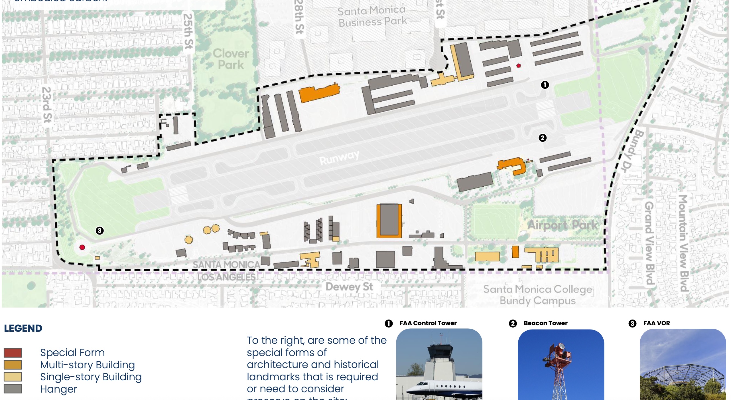
What might the short-term calendar for park development look like? As I wrote in my posts on land and money, first we should look at the easiest land to convert into a park, namely the runway, and at the money that will be available from local sources, such as airport leasing revenues, park user fees, and, possibly, water and other environmental funds. Some revenue sources, such as a café, can be included because they are consistent with parks and can be consistent with Measure LC if zoning is amended.

Then we should be thrifty, and plan a “starter park” that we can build with available funds.

There is a lot that can be done “on the cheap.”

San Francisco this spring created and opened a 50-acre park, called Sunset Dunes, by closing a highway that ran up the western edge of the city, along the Pacific. Closing the highway was controversial, but was approved by almost 55% of voters.  Notably, San Francisco opened the park before starting its long-term planning process; the city’s parks department, working with a budget of about $1 million, and helped by volunteers, built basic amenities. According to the New York Times (this article might be behind a paywall), in the first month more than 150,000 people visited the park.

Directly relevant to converting our airport into a park, the National Park Service converted Crissy Field, a former military airport, in San Francisco into an approximately 100-acre urban park in the 1990s. The cost then was about $40 million, more than half of which came from philanthropic sources. The City of Chicago converted its local airport, Meigs Field, into Northerly Island Park, also for a reasonable price.

There is a role for big plans, but let’s not allow long-term perfection to stymie shorter-term good. A park with portable toilets before the plumbing goes in is better than no park.

Thanks for reading.

The second factor in building a great park at Santa Monica Airport: money

I suspect that many you reading this joined the 5,000 demonstrators who jammed Palisades Park on Saturday for the “No Kings” rally. Leaving aside the bigger issues like whether a nation conceived in liberty and dedicated to the proposition that all men are created equal can long endure, the rally sure showed the importance of parks and other public spaces.

The crowd Saturday in Palisades Park. Imagine great public events on a great lawn at the new park.

As I wrote last week, the de-privatization of Santa Monica Airport into that paradigm of a public space, a great park, will depend on three factors: land, money, and time. I wrote about land in my last post. Now, money.  

First, context. Courtesy of a parks bond 99 years ago, Santa Monica owns the land at the airport. In any developed urban environment, land is the most expensive element of a park. Done.

The City also owns the buildings on the airport, from which it has, since regaining control of the buildings in 2015, earned tens of millions of dollars from leases to non-aviation businesses. This income will continue once the airport closes.

Widening the context, this is a wealthy subregion of southern California. The Westside of L.A., including Santa Monica, is the second largest jobs center in the region. Property values, both commercial and residential, are among the highest in the state. The rate of millionaires per square mile is high.

Widening the context further, parks are good economic investments. Many studies show how parks increase property values and attract investments, and thus increase tax revenues. They improve public health, lessening healthcare costs, They provide services, such as for recreation and environmental mitigation, that have economic values. For tourism centers like Santa Monica, they attract visitors.

I bring up these contexts, local and general, to say that if you are worried about whether there will be enough money to build a park on land we already own in one of the richest areas on the planet, take a deep breath. The idea that there will not be enough money to build a park at the airport is simply fear talking. Have we lost the ability to have a positive vision for the future?

The positive context doesn’t mean, however, that money doesn’t need to be found. It is additional good news, though, that we have more than three years before the airport closes. Time to work on financing. Time, however, also adds uncertainty. The further we look into the future, the more speculative the financing picture becomes.

It is important to focus on realistic sources of funding in the relatively short-term, five to ten years after the airport closes on Jan. 1, 2029. What shouldn’t happen is that anxiety about money causes the City to make decisions (or deals) that compromise the vision of a great park. A vision that may be realized over decades.

I will try here to be as realistic as possible, but with one caveat: the City’s park planners have not yet released an economic analysis that is part of the planning program, or figures about the cost of building specific park features. The City has engaged HR&A Advisors, the City’s go-to firm for financial analysis, to prepare a study. Once the study is released, I may want to update what I am writing now with more detail.

Let’s start with what we know: the revenues that the City earns from leasing buildings to non-aviation businesses. At present, these gross revenues are about $15 million, of which about half goes to operating expenses, leaving about $7 million of surplus. These revenues only become available to the City if the airport closes; otherwise, under FAA rules, the money can only be spent at the airport.

These lease revenues will be available to maintain and operate the park, but the City can also issue bonds against them to pay capital costs. For instance, $80 million borrowed at 4 percent for 30 years would be amortized at about $5 million per year. (Caveat: we don’t know what interest rates will be four years from now.)

There are also means to generate operating funds for the park that are consistent with park purposes. These include user fees for facilities, such as sports fields and other recreational facilities, and income from concessions, such as cafés, that City Council can permit under Measure LC with a zoning overlay for the park. These revenue sources can be predicted and planned for now; staff to its credit has solicited “letters of interest” from organizations that can use the park. (And right now: please, let’s reopen a restaurant where Typhoon was!)

There are other governmental sources that can be considered at this early stage, depending on planned uses. For instance, water features have always scored high on public surveys about what to include in the park: there could be water bond or other infrastructure money available depending on whether water features at the park can serve water conservation purposes.

Philanthropy has traditionally played a major role in the funding of parks, and there are many wealthy people who live in Santa Monica and nearby. Philanthropy enabled Santa Monica to build the Annenberg Beach House, and philanthropy endowed the Broad Stage. In the long run I suspect philanthropy will pay for significant features at the park, but unless a major benefactor comes forward now (such as what happened with Banning Ranch in Orange County), we won’t be able to predict what philanthropy might pay for until we have specific projects to be funded.

Another source to be considered, but it’s too early for any action, would be a parks bond. Santa Monica voters have been generous with bond funding for infrastructure, and funding specific projects could be quite popular, but as long as municipal infrastructure bonds need a 2/3 vote to pass, bond funding is problematic.

Finances since Covid have been tight for Santa Monica. We don’t know if the important international tourism sector of our economy will rebound soon. High interest rates are stifling development. Santa Monica has been described as “broke,” and the budget makers are looking for savings everywhere.

However, we should remember that before the pandemic, Santa Monica had one of the strongest economies in the country, with high per capita tax revenues and a triple-A bond rating. The City may be running a deficit, but the City has paid out hundreds of millions of dollars to settle Eric Uller abuse cases. If Uller had been stopped decades ago, that money by itself could pay for a big park.

My next post will look at the third factor in building the park, time.

Thanks for reading.

Building a great park takes three things: land, money and time

The two posts I wrote last week about building a great park to replace Santa Monica Airport were gloomy, focusing as they did on problems with the planning process. Such issues, though, should not diminish the joy we should be experiencing now. (Joy about converting SMO into a park; there’s a lot of pain going around about everything else, and I urge my fellow Santa Monicans to attend the No Kings rally here (or one elsewhere) on Saturday.)

We Santa Monicans have within our power the possibility of building a large and wonderful park, one that’s big enough to both nurture nature and furnish wide opportunities for recreation and community, in the middle of the “Plains of Id” (to borrow Reyner Banham’s moniker for the urban L.A. flats from his classic book, Los Angeles: An Architecture of Four Ecologies).

The L.A. flats, including Santa Monica, have few parks because under the Spanish/Mexican land grant system little land was publicly owned. Then, after Yankees arrived and married into the landowning families, the ranchos were subdivided into towns and other settlements. As a result, public spaces are few and far between.

We owe a great debt to the residents of Santa Monica who, 99 years ago, voted to tax themselves to buy land for a park, land that is now conservatively valued at $2 billion and which at that price could never be obtained for public use again. When the airport closes at the end of 2028, this land will be returned to the public after being privatized for 80 years.

We can build a great park, but we need to be smart about it. Above all, we need to keep the public confident that we will succeed. To do that, we need to manage both resources and expectations.

There are three factors that will determine how we will build the park: land, money, and time. The three need to be coordinated, but for now I’ll treat them one-by-one.

Land. Here’s a map of the site from the Site Inventory prepared for the current planning process.

The 192 acres of the airport site are within the dotted lines. The gray area of the runway, the white open areas near the runway, which are mostly tie-down areas, and the green areas at the end of the runway, are the areas on which this post focuses.

If you are going to build a park on this site, and you don’t have an unlimited budget, the logical place to start is the runway, along with the tie-down areas where planes are parked. Why? Because these areas are big and flat and empty, and easily connected to the existing Clover and Airport Parks.

Tie-down area adjacent to runway.

Once any environmental issues have been evaluated and remediated, the runway and tie-down areas will be the easiest and least expensive parts of the site to develop. Already at each end of the runway 750 feet of tarmac have been removed.

Part of the 1500 feet of the runway where tarmac was removed after the 2017 settlement with the FAA.

It seems obvious (to me at least) that the starting place for planning the park should be the runway. However, the three scenarios produced by the planning process all show fully-developed parks on the whole site. No plan like those in the three scenarios will be built all at once, or even in the near future after airport closure in 2029. The problem with dreaming about the whole park is that trying to imagine how all of the park amenities would be paid for is driving the planning process, turning much of the site into “revenue-generating” uses.

The process should start the other way around, with what might be possible to build in stages. The planning should start with the easiest land to build on.

A lot of park amenities can be built on flat land, and for not a lot of money. Sports fields, for instance. They don’t need to be fancy, with artificial turf (which has its own environmental issues). If there are enough fields (in combination with those at the existing parks), the use of them can be staggered so that grass will have a chance to recover between seasons of use. Grass fields, as opposed to artificial turf, don’t need to be fenced off, and can be used casually, like for picnics and running around, when not being used for games. Temporary irrigation systems can be used until permanent irrigation can be installed.

Open meadows, and hiking and biking paths and trails can also be built inexpensively on flat land. Think about a bike path, which might even accommodate shuttle buses, that could use a strip of existing tarmac to connect the Santa Monica College Bundy campus and Airport Avenue with Ocean Park Boulevard.

And let’s not forget the (inexpensive) park amenity that might be what Santa Monica’s apartment-dwellers need most: picnic tables.

Trees can be planted to provide shade.

To save money upfront, we can use portable toilets before we install the plumbing for permanent facilities, and we can invite in food trucks and pop-ups before we build cafés. (Cafés can be permitted under Measure LC if City Council amends the City’s zoning on parks. Meanwhile, let’s return a restaurant to where Typhoon was.)

While we are building a park on the runway and tie-down areas with re-wilded open spaces and meadows, sports fields, hiking and bike paths, picnic tables, and the like, we can start planning more ambitious amenities for the rest of the land, or for the next iteration of the runway land.

And we can use that time to line up the money for doing so.

Oh, yes, time and money. I’ll get to them in upcoming posts.

Thanks for reading.

Planning a park at Santa Monica Airport: keep it real

As I discussed in my post on Monday, the process for planning the conversion of Santa Monica Airport into a park has produced three aspirational “scenarios.” While no one would expect or desire that Sasaki, the park designers hired by the City, would have by now a definitive plan, so far the process has not generated plans that would likely be built in the five, or 10, or even 15 or 20 years, after the airport closes Jan. 1, 2029.

The upshot of these “big plans” is the inclusion of extensive “revenue-generating” uses in two of the three “scenarios.” These uses would require a vote to amend Measure LC, although the City Council could use zoning amendments to make some revenue-generating uses, those that are are consistent with parks, LC-compliant.

Other suggested uses could not be made compliant by the council. They include (in one or both of the non-LC compliant scenarios) housing or commercial development, a hotel, and/or a Hollywood Bowl-sized amphitheater. These uses are themselves highly contingent because they also would need to be planned, through a public process, and then approved by voters, and then, of course, financed.

So at a time when City Council needs to focus on reality, we have speculation (aspirational designs) piled on speculation (hypothetical revenue generators).

Meanwhile, adding to the speculation is that the airport won’t close for more than three and half years. We don’t know what the City’s budget will look like then, we don’t know what interest rates will be, we don’t know what regional, state or federal grants might be available, and we don’t know – well, I could go on.

Perhaps I should have more faith (and patience). Based on a conversation I had with a Sasaki designer at the City’s May 17 event where the three scenarios were unveiled, and on remarks Amber Richane, from the City’s Public Works Department, recently made to the Santa Monica Democratic Club, it appears that Sasaki and staff will be generating a “phasing” plan for park development. This will, apparently, include a “Phase Zero” for the first five years or so. Phase Zero would include environmental remediation, if necessary, and park development that can be paid for from leasing revenues from the airport (which are considerable). (Ms. Richane also said there could be money for water projects from a different fund.)

Let’s hope this phasing plan will be released before the City Council meeting July 8. Then the council will pick and choose what elements will go into the plan that will be subject to environmental review. This council needs to focus on what can be done when the airport closes, not what might happen long after they have termed out. The preferred alternative for the EIR must be LC-compliant.

In the meantime, let’s consider revenue generation. Specifically the idea that housing development can help pay for the park. As supporter of housing development I have always been skeptical when I hear people assume that housing development can pay for anything other than its own development. Why? Maybe it’s because over the past 30 years the two most prolific for-profit housing developers in Santa Monica, Craig Jones and Neil Shekhter, both ended up in some form of insolvency. As for affordable housing, it requires its own subsidies.

Development is a tough business.

But then, historically nearly all housing development, especially since World War II, has required subsidies. Do you think that suburban developers would have made so much money without the highways, sewers, water systems, and other infrastructure government built, or the home loans government insured?

There is a lot of anxiety going around, much of it propagated by pro-airport people, but some of it coming from pro-housers, about how Santa Monica can’t afford to build a park, even though it already owns the land, the most expensive element of park-building. No one, however, seems to talk about how difficult and expensive it would be to build housing at the airport.

Consider the infrastructure costs. To give Sasaki and staff credit, in their scenarios they located all of the revenue generating uses on land at the airport that is already to some extent developed, but do we expect that those areas with their crumbling hangars and other sheds and shacks have the water and sewer and power infrastructure to support extensive housing?

Sheds at the airport.

Consider that there’s no connection with transit corridors except on the northern and eastern edges (and not good connections there, either). On the southern parts of the airport, where the scenarios locate a lot of development, for vehicular access there is only Airport Avenue, with, on the western end, its woeful intersection with 23rd Street, Dewey Steet, and Walgrove Avenue. So who pays for the transportation infrastructure? (Yes, the park will also need more access, but not on the level of thousands of units of housing.)

To use a phrase I’ll borrow from an email sent to me by a pro-housing, urbanist friend, putting affordable housing at the airport would be to put low-income people “away from the public transit backbone of Santa Monica.”

One reason real estate development is a dicey business is that it’s hard to predict interest rates over the lengthy periods of time it takes to get permits and to construct housing. At the moment there is a pile of approved housing developments in Santa Monica that are stalled because of current high rates. We don’t know what interest rates will be when it comes time to “generate revenue” for the park.

The proponents of housing at the airport say that state housing element law will require the City to use airport land for housing under the next Housing Element cycle. This is false, as the City will be able to satisfy future state housing requirements elsewhere (as shown in the 2010 Land Use and Circulation Elements of the General Plan).

Meanwhile the housers fail to take into account the impact of the Surplus Land Act (SLA) on financing housing.

Under the SLA the City cannot dispose of the airport land, which includes selling it or leasing it for more than 15 years, without, and I admit I’m simplifying here (the law is complex), offering the land to affordable housing developers, who then would have the right to negotiate with the City for a reasonable price to acquire the land. The sounds good for affordable housing developers, but at what price? What’s reasonable? Realistically, affordable housing developers would need to get the land for free.

Consider for-profit developers. What developer can get financing if the developer only has control over the property for 15 years? If the financing needs more than 15 years of control, then the developer is thrown into the unknown of the City having to negotiate with affordable housing providers. In any case, it’s a long and complicated process. Housing development would not be a quick way of generating revenue.

I get it that pro-housers couldn’t care less if housing would subsidize the park. As I said, as a long-time houser, I’m always skeptical of putting more burdens on housing development. But what the City Council asked the planners for was development that would subsidize the park, and it’s on that basis that the planners’ scenarios should be evaluated. Independent of that, because of the infrastructure issues, housing development on the airport land would be significantly more costly than development elsewhere in the city.

Next week I’ll venture into some speculation of my own – on how the City could start building the park in 2029.

Thanks for reading.

Turning Santa Monica Airport into a park: let’s not bite off more than we can chew

Santa Monica Airport is set to close December 31, 2028, and the City’s process to reclaim the city-owned land at the airport and convert it to public use as a great park, the “Santa Monica Airport Conversion Project“, is underway. Sasaki, the consultants hired by the City at the end of 2023, and staff in the Public Works Department have stuck to the schedule originally agreed on. In January City Council adopted “Guiding Principles” and directed Sasaki and staff to come back to council this summer with three different scenarios for the future or the site. From these the council will pick and choose elements to be included in a plan that would by the end of the year be ready for environmental review. (The council’s meeting to do this is scheduled for July 8.)

Over the course of the process, as is de rigueur, Sasaki and staff have conducted considerable public outreach. As is typical the process has made few happy.

In case your memory needs refreshing, the City has been trying to close the airport since the early 80s, when the Federal Aviation Administration (FAA) required the airport to service jets. Under a 1984 agreement, the City gained the right to close the airport in 2015, but at some point after 2000 the FAA disputed the City’s right to do so. Litigation ensued. The aviation industry, fearing the City would win in court, collected signatures to put a measure on the 2014 ballot (“Measure D”) that would have perpetuated the airport by taking away the City Council’s power to close it. The City responded with a counter-measure, Measure LC (“LC,” for “local control”), which provided that once the airport closed, the land could only be developed for parks and recreational purposes, unless other development is approved by a vote of the people.

In the election, Meas. LC defeated Meas. D by a 60-40 margin. Three years later, the City entered into a new agreement with the FAA that definitively gave the City the power to close the airport at the end of 2028.

Disclosures: I am on the board of the Santa Monica Airport2Park Foundation (A2P), which was formed after the election by the committee that ran the campaign in support of LC and against D. We formed A2P to keep the vision of a park alive until the City could close the airport. I am also on the board of the Santa Monica Great Park Coalition (GPC), which was formed last fall. The GPC is a grouping mostly of organizations whose members want to use the park (such as sports organizations) or who believe the park is important for environmental or other social reasons. Our more than 60 organizations represent more than 20,000 members.

Getting back to planning the park, the extensive public process has made few happy. Which is unfortunate, but not unusual. To understand the reactions to the process, you need to know that the politics of the conversion process in Santa Monica have involved, at least so far, not much about the decision to close the airport, but instead whether any of the reclaimed public land should be used for housing.

At first pro-park people, like us in A2P and the GPC, were pleased because the process, in the form of surveys and a well-attended workshop in December, showed tremendous enthusiasm for the park. It was exciting and inspirational to see all the ideas for how these 192 acres, which have been privatized for so many years, could be returned to parkland. (In case you don’t know, the City originally purchased the land in 1926 with a parks bond, and the land was a park until the federal government took it over before World War II so that Douglas Aircraft could build planes there.)

Participants at the Dec. 8, 2024 workshop. And estimated 800 people attended, the largest turnout for a Santa Monica planning event in anyone’s memory.

The public process did not show widespread support for building housing on the land, and this result did not please housing proponents. They claimed that the surveys were biased against housing, in part because the surveys identified housing, along with other possible uses of the land, as requiring voter approval under LC. (As an aside, but an important one: many people oppose any effort to amend LC before airport closure, because of the well-grounded fear that in response the aviation industry would come back with a new Meas. D, and because a vote to amend LC now would effectively freeze the planning process for the park. For those reasons it made sense for the planners to identify in the surveys uses that would require a vote.)

Then recently at a Planning Commission meeting, the pro-housing complaints about the process were expanded when UNITE Here, the union representing hotel workers, most of whom are Latino and many of whom have limited English, had been excluded from the process because of inadequate outreach in Spanish and for other technical reasons. UNITE Here is a supporter of the most prominent proposal so far for building housing on the land, called “Cloverfield Commons,” which calls for using half the land to build 3,000 units of affordable housing.

No process is perfect, of course, but this reaction from the pro-housers was not unusual: people who don’t like the results of a process challenge the process. But recently we on the pro-park side have had our own complaints about the process, namely that Sasaki and staff were ignoring the results of their public outreach.

On May 17 Sasaki and staff, at a big event at the airport, released the three scenarios they had prepared in response to council’s direction back in January. Two of the three included considerable amounts of housing. This stunned the pro-park side, who felt blind-sided.  

Why? At the meeting in January City Council had directed that one of the three scenarios be compliant with Measure LC. They directed that another of the three would be non-compliant by using development – specifically,  to include “some housing” – to support the park financially. The third scenario was left somewhat vague: no one on council or staff said it should include housing, but it was understood that it would not be fully compliant with LC either. That’s because there is a gray area concerning compliance with LC. There are uses that are consistent with what a park is, such as a café or an amphitheater, but which are not currently included in the definition of “park” under the City’s zoning. City Council, however, can amend those ordinances to include other uses consistent with parks, which would then make those uses compliant with LC.

So when two of the three scenarios included lots of housing, not just “some housing” as City Council had asked for, that was a big win for the housers notwithstanding their feelings about the process. It’s natural, however, that we on the park side wonder if our input, and the overall enthusiasm for the park, had been listened to.

So how did this happen?

From the beginning of the process City Council has said that plans for the park should be financially feasible. This is a good thing, and one that we pro-parkers advocated for when the planning process was being started. We don’t want the public to be discouraged by a beautiful, but pie-in-the sky plan that can’t be built because it costs too much.

But that’s not how these processes work. Consultants ask the public what they want, and the public responds by asking for a lot. Designers like to design beautiful things (“make no little plans” as Daniel Burnham (in)famously said), and you can guess what happens.

The result of the direction from the council for financial feasibility was not a starter park that could be built when the airport closes and then expanded over the following years, but two highly aspirational scenarios. The “financial feasibility” solution, if they were going to be built quickly, without waiting for other sources of funds, was to include considerable amounts of on-site “revenue generation.” (While these revenue-generating areas on the maps showing the scenarios were not specifically designated as housing, no one would expect that they would be offices or something else.)

This controversy is unnecessary. The problem with this process, at least as described to the public so far, is that everything is focused on what a completed park would look like, so that the costs of building that park, and the financing that would be available, need to be computed and accounted for now. But the airport is not going to close until December 31, 2028 – more than three and a half years from now – and nothing on the scale shown in the scenarios is likely to be under construction soon after closing.

Not only that, but the idea that housing could pay for the park doesn’t make sense.

I’ll continue this discussion with upcoming posts.

Thanks for reading, and please stay tuned.

At the May 17 event, bus tours were given of the usually off-limits runway area. This photo shows some of the land “liberated” when the City was able to shorten the runway after the 2017 agreement with the FAA. It shows just a small part of the potential for the park.